


Canal_de_l'Argens_est

essius
User
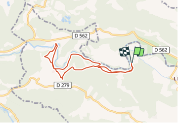

Length
7.7 km

Max alt
165 m

Uphill gradient
135 m
Km-Effort
9.5 km

Min alt
108 m

Downhill gradient
135 m
Boucle
Yes
Creation date :
2021-10-12 07:15:53.917
Updated on :
2021-10-12 07:15:53.917

FREE GPS app for hiking
 SityTrail
IGN / Geographical institutes
SityTrail Plus
The world is yours!
About
Trail of 7.7 km to be discovered at Provence-Alpes-Côte d'Azur, Var, Le Thoronet. This trail is proposed by essius.
Positioning
Country:
France
Region :
Provence-Alpes-Côte d'Azur
Department/Province :
Var
Municipality :
Le Thoronet
Location:
Unknown
Start:(Dec)
Start:(UTM)
277666 ; 4817729 (32T) N.
Comments